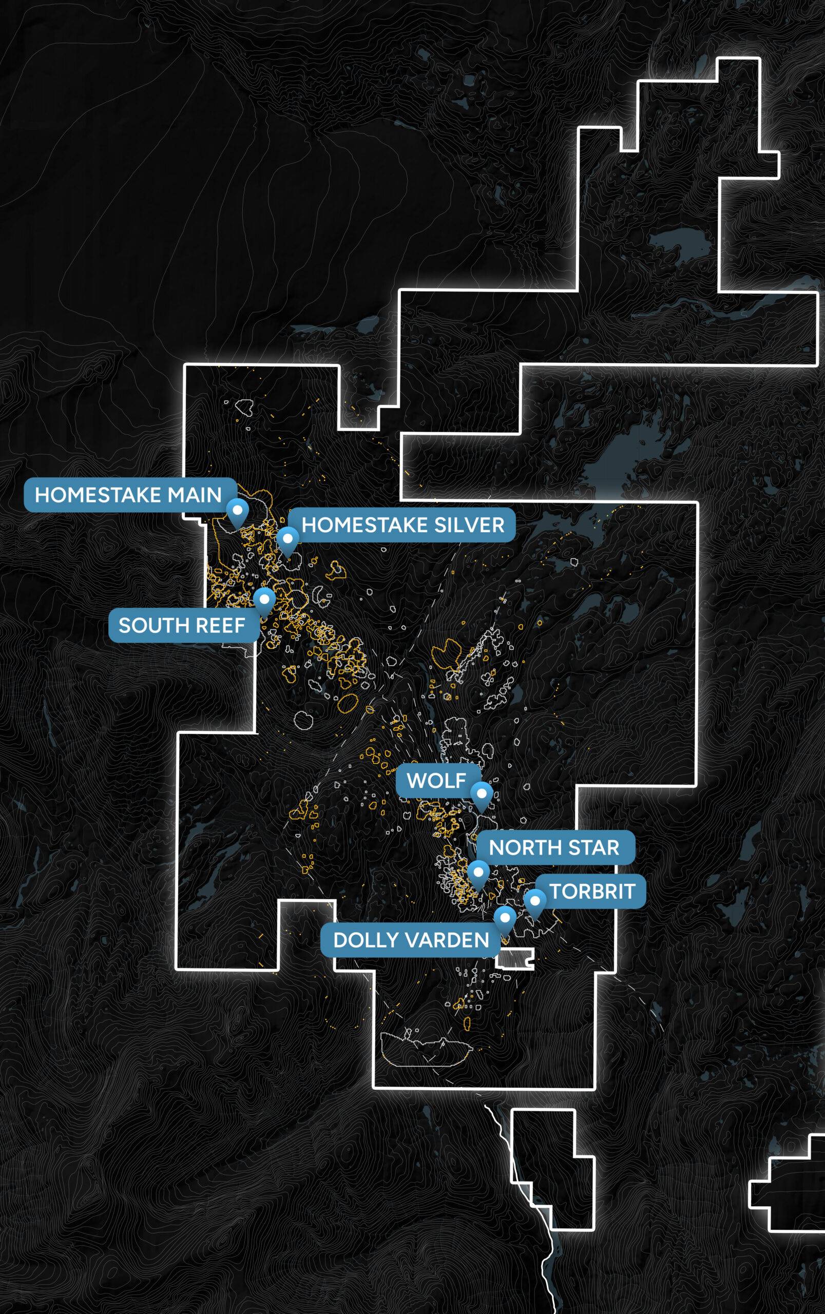
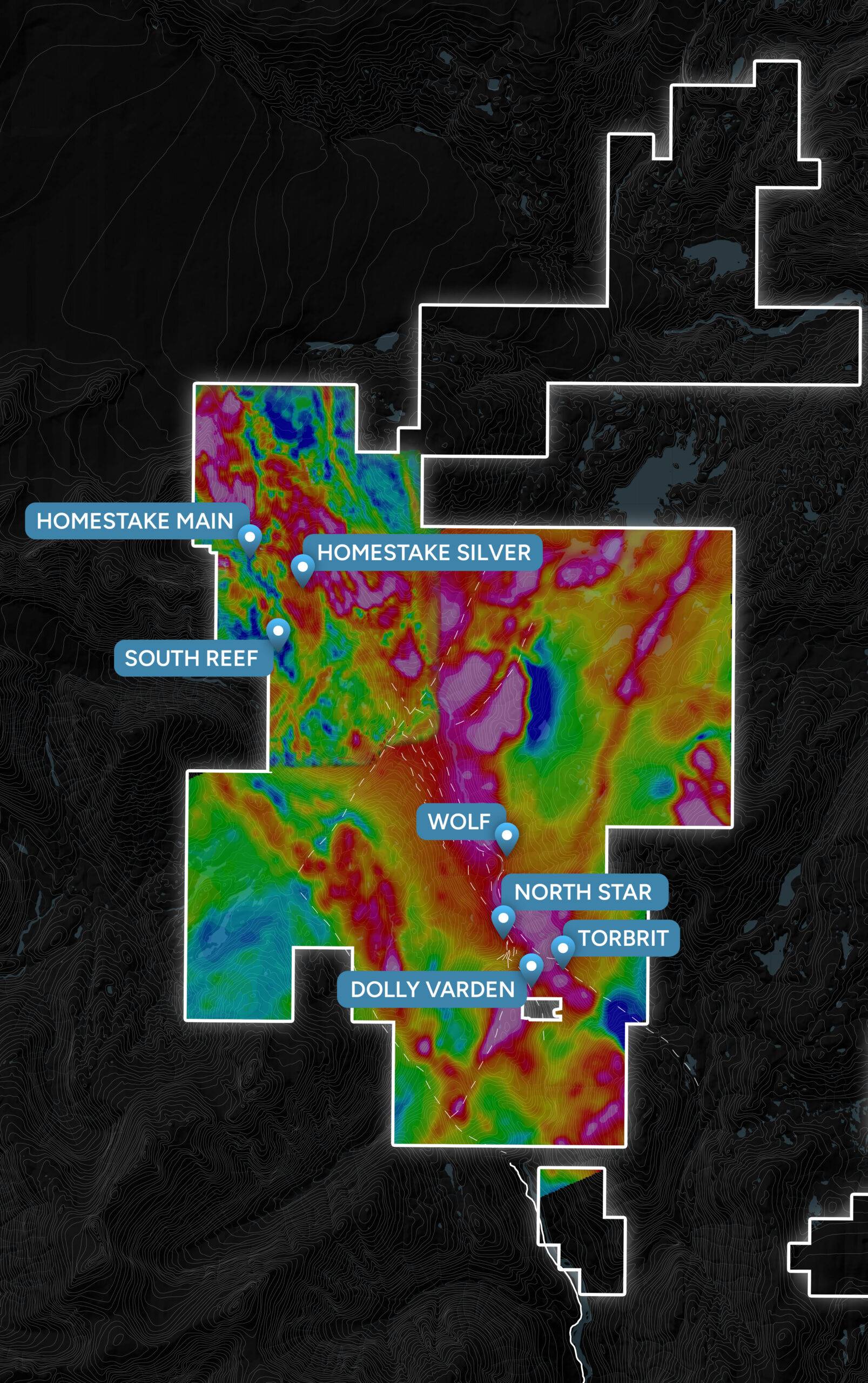
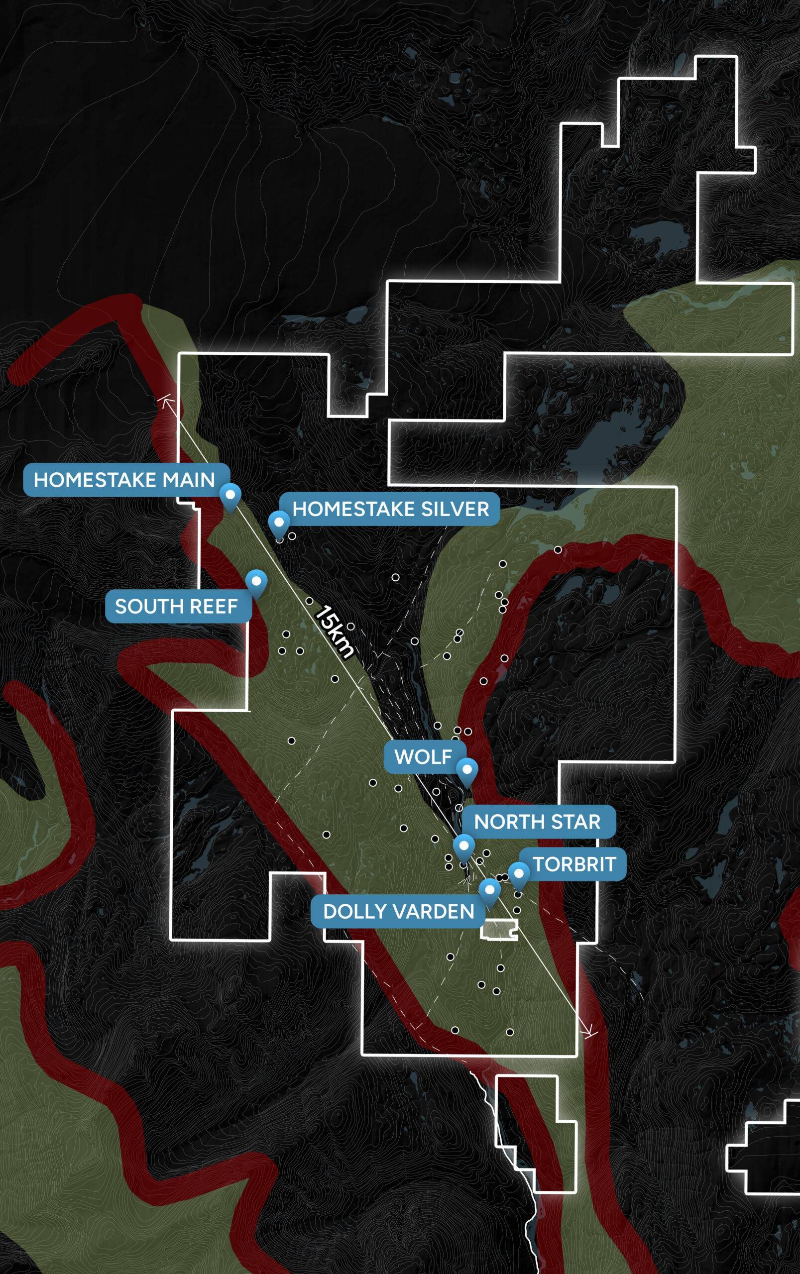
Dolly Varden Silver’s 100% held, 163 sq. km. Kitsault Valley project is located in the southern tip of the Golden Triangle of British Columbia, just south of the high-grade Brucejack and Eskay Creek gold mines.
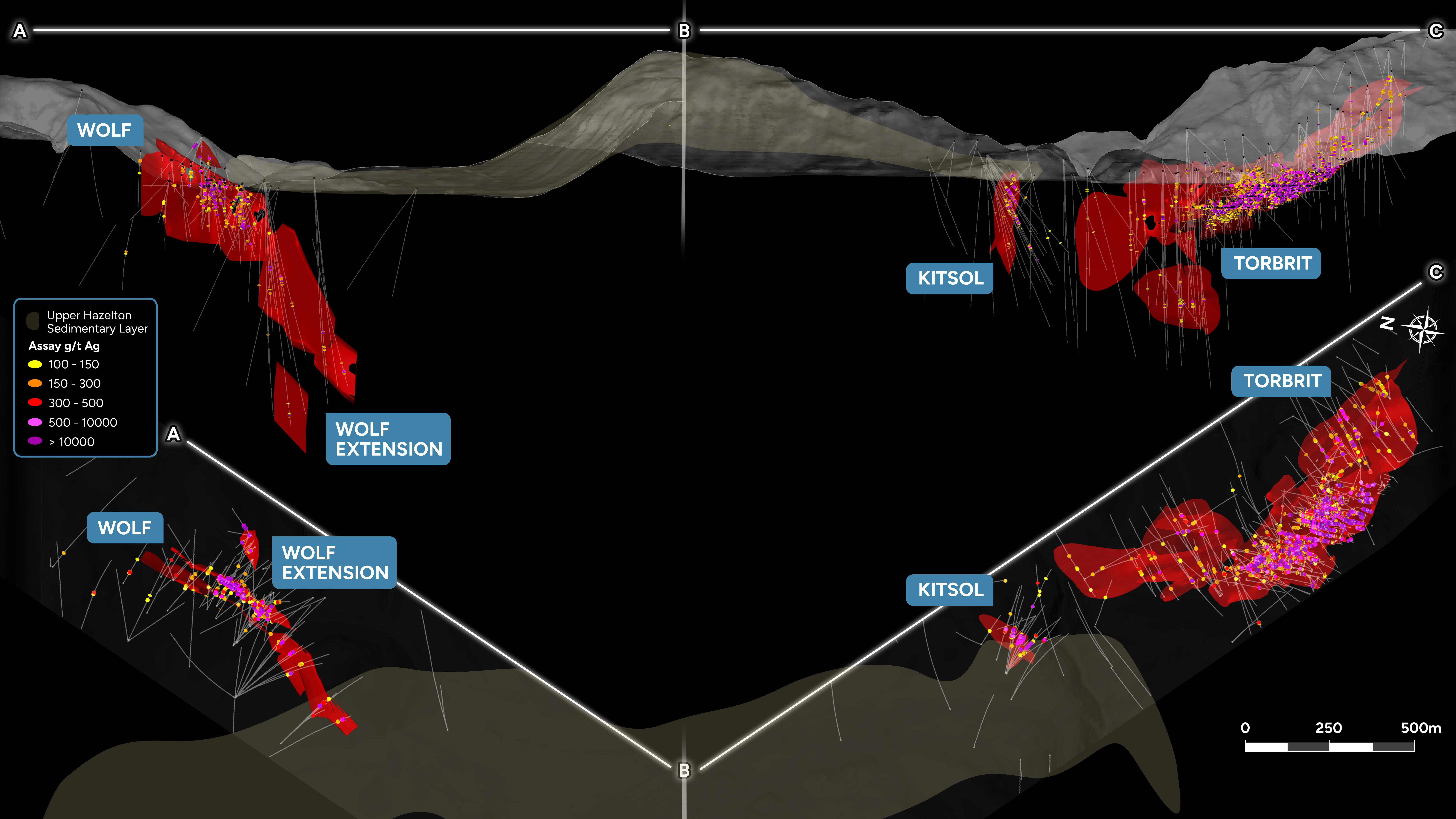
The project hosts a high-grade mineral resource of silver and gold and is considered prospective for hosting further precious metal deposits.
The project was formed on February 25, 2022 as a result of Dolly Varden Silver Corp.’s acquisition of the adjacent Homestake Ridge project from Fury Gold Mines Ltd. (News Release).
The combined project consolidates the highly mineralized Kitsault Valley Trend along with seven precious metal deposits thereby transitioning the Company’s 100% silver project to a project with 50/50 silver and gold resources measured by value.
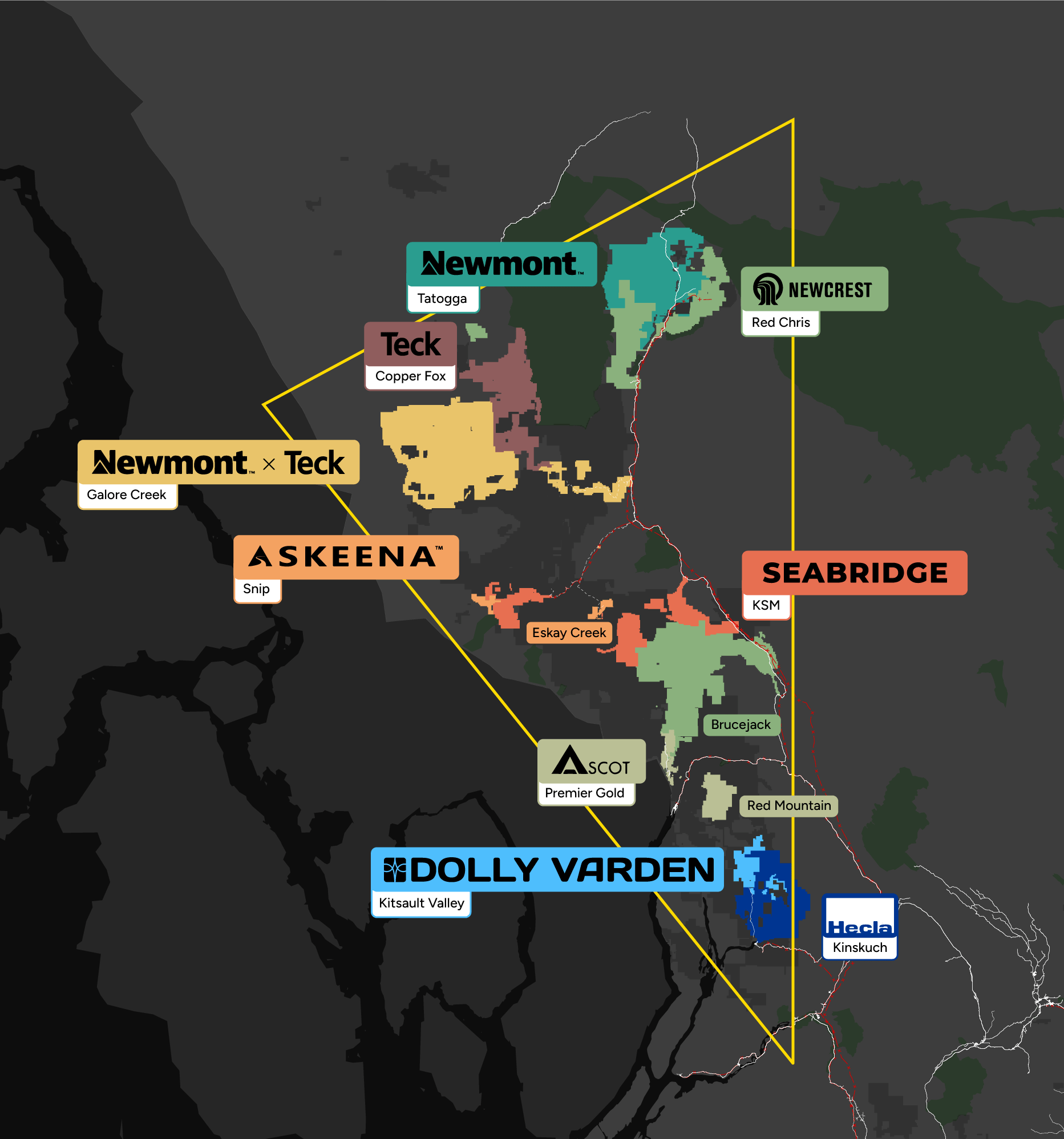
The project is rare having significant resources of silver in a safe jurisdiction.
Benefits to shareholders of the acquisition include:
- A larger project increases its economic viability
- Economies of scale – savings on exploration, studies, permitting, development and operation
- Consolidates 15 kms of strike for exploration including 5.4kms of underexplored ground between the Wolf and South Reef deposits.
The Company presently has two technical reports for the Kitsault Valley project, one for the Dolly Varden silver resource and one for the Homestake Ridge gold and silver resource.
Combined silver and gold resources of the Kitsault Valley project include:
In preparation for filing a technical report for the Kitsault Valley project in early 2023 along with an updated and united resource calculation, Dolly Varden plans to complete a significant drill program in 2022 which is expected to include:
- Infill drilling at deposits on Dolly Varden and Homestake Ridge to increase mineral classifications from Indicated and Inferred to Measured and Indicated
- Step-out drilling from known deposits to increase mineral inventories
- Exploration drilling of the underexplored 5.4km area between the known deposits
For further information on the combined Kitsault Valley project, please refer to the Dolly Varden Resources and Homestake Resources pages on this site.
The Dolly Varden comprises the 88 sq. km southern half of the Company’s 163 sq. km. Kitsault Valley project located in the Golden Triangle of Northwest British Columbia. It features a high-grade 100% silver resource.
It includes four known precious metal deposits: Wolf, North Star, Dolly Varden and Torbrit
Two of the deposits are past producers:
- Dolly Varden Mine (1919-1921) – 1.3 million oz at 1,109 g/t Ag (epithermal silver veins)
- Torbrit Mine (1949-1959) – 18.7 million oz at 466 g/t Ag + base metal credits (volcanogenic low-sulphidation with cross cutting epithermal veins)
The project is located adjacent to Helca Mining’s 594 sq. km. Kinskuch property and includes infrastructure such as a 25km access road to deep water and electricity at the nearby town of Kitsault.
Dolly Varden Resources
- Effective May 8, 2019, Apex Geosciences Ltd.
- 150 grams of silver per tonne (g/t Ag) cutoff grade
- Indicated and Inferred Mineral Resources are not Mineral Reserves. Mineral resources which are not mineral reserves do not have demonstrated economic viability. There has been insufficient exploration to define the inferred resource as an indicated or measured mineral resource, and it is uncertain if further exploration will result in upgrading the resource to a measured resource category. There is no guarantee that any part of the mineral resource discussed herein will be converted into a mineral reserve in the future.
Past production at the Dolly Varden mine includes ore direct shipped to tidewater whereas Torbrit produced a silver concentrate.
2017 metallurgical test work showed strong recoveries and production of a clean concentrate, low in deleterious elements.
Property Geology
The geology underlying the Dolly Varden property consists of volcano-sedimentary rocks belonging mostly to the lower and middle Jurassic Hazelton Group. These include intermediate volcanic and volcaniclastic rocks of the Betty Creek Formation and bimodal volcanic and sedimentary rocks of the Salmon River Formation.
The principal silver-base metal deposits of the Kitsault River valley have been interpreted as vein mineralization by early workers. Devlin (1986) reinterpreted the main deposits to be volcanic exhalative in origin. Deposits of this type are formed as sub-aqueous hot-spring type deposits on the seafloor, as products of hydrothermal solutions that have vented from sub-seafloor fracture and fault systems. Furthermore, the silver deposits of the upper Kitsault valley are mapped with important geological similarities to the Eskay Creek deposit, providing an analog for exploration on the property.
The most prominent mineralized zone on the property is an aerially extensive horizon of chemical sediment (“exhalative”) mineralization, known as the Dolly Varden-Torbrit Horizon (the “DVTH”) that extends from the Dolly Varden mine, on the west, passing through the North Star underground workings and continuing into the Torbrit mine, on the east. The DVTH exhalative body forms an almost continuous sheet, ranging in true thickness from 3 to 38 m, which extends from the Dolly Varden West zone to Moose-Lamb. Syn-depositional as well as post-dispositional faults have created a number of basins that divide the DVTH into offset blocks.
Separate from the DVTH body, the Red Point zone (on the western fringe of the upper Kitsault Valley) and the Wolf (on the eastern side of the valley) each have geological similarities to the targeted hydrothermal vein and sub-aqueous hot spring geology but are interpreted to share a position higher in the volcanic stratigraphy than the DVT horizon.
Eskay Creek Model Comparison
The Torbrit deposit which hosts the bulk of the resources on the property is similar in style to an Eskay Creek type deposit that is a striking example of a class of high-sulphidation VMS deposits, with Torbrit being a low-sulphidation example. These VMS deposits form near sub-aqueous hot-spring vents where base and precious metal-rich hydrothermal fluids exhale onto the seafloor under shallow depths of seawater.
At the Eskay Creek deposit, stratiform (bedded) layers of precious metal-rich chemical sediments and massive sulphides accumulate near vent areas and become the source for clastic sulphide debris in adjacent areas. The bedrock in the vent areas are underlain by precious metal rich feeder veins, stockwork veins and strong alteration.
A Schematic diagram, modified from Hannington, 1996, demonstrates the geological and spatial characteristics of the Precious Metal Rich VMS deposits with the key features as mapped at Dolly Varden. The DVT Exhalite which hosts the Silver deposits at Dolly Varden – North Star – Torbrit are correlated with the Barite-Silica Cap, and the Redpoint Feeder Zone correlates with the footwall stockwork alteration feeder zone.
Big Bulk & Midnight Blue
Big Bulk can be found just east of the main Kitsault Valley project area and forms part of the project. Big Bulk consists of 2,640 hectares in 7 mineral claims covering a copper-gold porphyry and skarn prospect on the southern shores of Kinskuch Lake, approximately 5 km east of the Dolly Varden Project and 23 km northeast of the village of Kitsault.
The Hazelton Group in the Kitsault area is the southern limit of a continuous belt of the the Stikine Terrane which has been shown to host large alkalic gold-copper porphyry deposits, of which the Galore Creek, Red Mountain and KSM deposits are examples. The Big Bulk copper-gold porphyry is interpreted to fall into the same age and mineralization category.
Intermittent exploration programs have taken place over several decades. Short historic drilling programs have been conducted by AngloGold Ashanti, Agnico Eagle, Teck Resources and Homestake Resources Corp. AngloGold Ashanti drilled hole AGA01 in 2009 and intercepted 0.31% Cu over 54 metres from 67 to 121 m, plus 4.0 g/t Au over 10 metres from 427 to 437 m, coincident with an IP chargeability geophysical anomaly.
As a separate mineral claim, but part of the Big Bulk Project, is the Midnight Blue claim. This location has a large copper-gold anomaly in talus fines and suggests the Big Bulk mineralization extends approximately 4 km from Kinskuch Lake southwards under ice cover to Midnight Blue. Two neighbouring companies, Hecla Mining Limited and an option by Libero Copper, hold mineral claims contiguous with Big Bulk that cover other southward extention of Big Bulk as well as other possible porphyry centers extending south towards the Kitsault Moly porphyry.
In 2017 and 2018, a joint study by the University of British Columbia and the British Columbia Geological Survey (BCGS) consisting of structural geology mapping was conducted over the Big Bulk area, with logistical support from Dolly Varden Silver. Results of this study draw parallels between the KSM system and the Big Bulk system in age and mineralization style as well as interpreting the Big Bulk/Kitsault Valley area as a sub-basin of the main Eskay Rift period.
Homestake Ridge comprises the 75 sq. km. northern half of the Company’s 163 sq. km. Kitsault Valley project located in the Golden Triangle of Northwest British Columbia and features a high-grade gold and silver resource. It includes three known precious metal deposits: Homestake Main, Homestake Silver and South Reef.
More than 90,000 metres in 275 holes have been drilled at Homestake Ridge forming a resource of high-grade gold and silver (along with copper and lead values) as follows:
- Canadian Institute of Mining, Metallurgy and Petroleum (CIM) Definition Standards for Mineral Resources and Mineral Reserves dated May 10, 2014 (CIM (2014) definitions), as incorporated by reference in NI 43-101, were followed for Mineral Resource estimation.
- Mineral Resources are estimated at a cut-off grade of 2.0 g/t AuEq.
- AuEq values were calculated using a long-term gold price of US$1,300 per ounce, silver price at US$20 per ounce and copper price at US$2.5 per pound and an exchange rate of US$/C$1.20. The AuEq calculation included provisions for metallurgical recoveries, treatment charges, refining costs and transportation.
- Bulk density ranges from 2.69 t/m3 to 3.03 t/m3, depending on the domain.
- Differences may occur in totals due to rounding.
- The Qualified Person responsible for this mineral resource estimate is Andrew Turner, P.Geol., APEX Geoscience Ltd.
South Reef deposit
On January 20, 2022, Dolly Varden Silver filed an updated Technical Report and Updated Mineral Resource Estimate for the Homestake Ridge Gold Project, prepared by Apex Geoscience Ltd.
Fury Gold Mines Ltd. Historic Preliminary Economic Assessment
The former project owner, Fury Gold Mines Ltd., completed a previous Preliminary Economic Assessment on the Homestake Ridge project with robust economics. This historic NI 43-101 compliant technical report dated May 29, 2020, prepared by Minefill Services, Inc. can be found by searching www.SEDAR.com.